Endurance22 Expedition (February 05 - March 20, 2022)
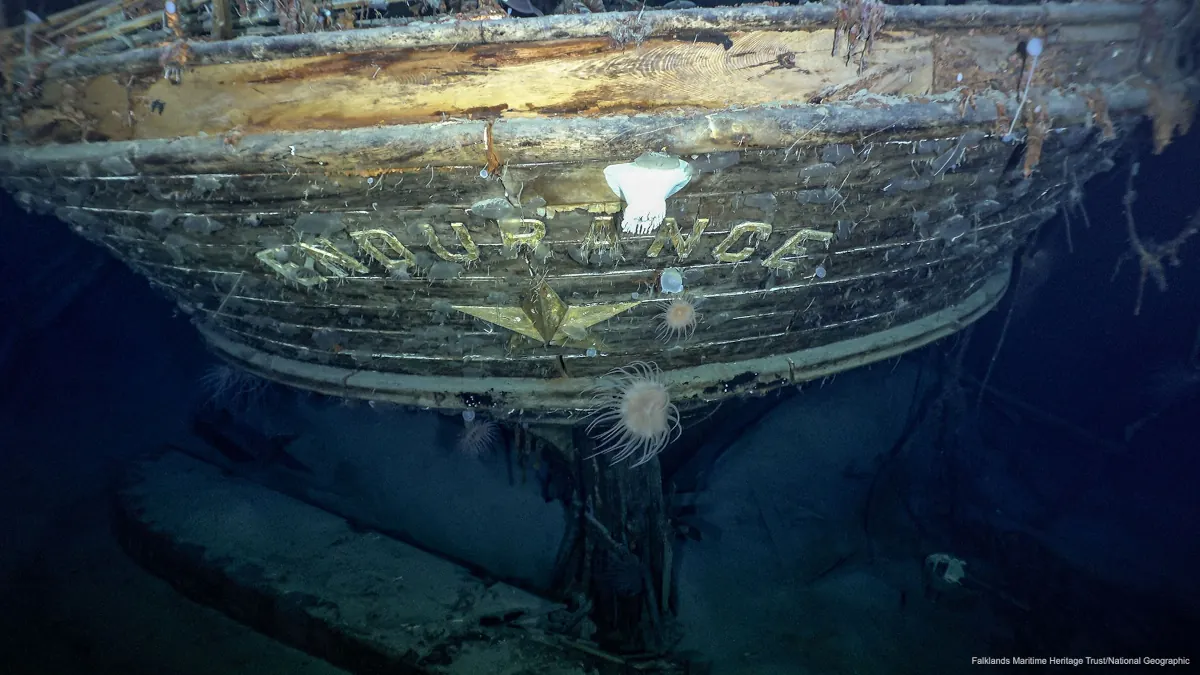
The Endurance22 expedition was a large-scale and interdisciplinary expedition to Antarctica, organized and funded by the Falklands Maritime Heritage Trust (FMHT) to locate, survey and film the wreck of Sir Ernest Shackleton's ship Endurance, which was lost in the ice in the Weddell Sea in 1915. On February 05, 2022 the international expedition team, consisting of an expert subsea survey team, logistic specialists, sea-ice scientists, and a marine archaeologist, left Cape Town on the South African research vessel SA Agulhas II for the Weddell Sea. Although the main focus of the expedition was to locate and survey the wreck of Endurance, a secondary focus was to carry out a comprehensive scientific program to study sea-ice parameters and the ship's response to the harsh ocean and ice conditions of the lower latitudes and ice-covered ocean. Another major component was the extensive outreach and education program that, continuing to this day, strives to excite the general public and especially young students about the story of Shackleton and his men and the fast-changing environment of the ice-covered Antarctic. Endurance was found 3008 metres below the ice surface on March 05, 2022.
Drift+Noise Polar Services was assigned to be the scientific lead of the expedition and played a key role in finding Endurance at the sea floor in the Weddell Sea. Shipwreck searches are inherently challenging and risky, however, surveying an area on the sea floor in thick ice cover requires careful planning, reliable data and knowledge about sea ice and its drift direction and speed. For any wreck search a survey area is predefined and surveyed with the under-water vehicle. The Endurance22 subsea surveying was especially challenging due to the drifting sea ice in the area. The Agulhas II is categorized as a Polar Class 3 vessel, which is not ideally suited for operations in regions with extensive multi-year ice, such as the Weddell Sea. Nevertheless, our team leveraged near-real-time, high-resolution ice information to significantly enhance the tactical operational capabilities, which paved the way for Ocean Infinity to conduct subsea activities using the Saab Sabertooth underwater vehicle in this harsh environment.
It is important to note that the Saab Sabertooth was capable of diving for "only" 9 hours at a time under the ice. In order for the surveys to cover the entire pre-defined search area reliable estimates of the sea-ice drift were required. With our unique expertise the Drift+Noise and science team was able to forecast sea-ice drift required for subsea operations and support the navigation officers in bringing the SA Agulhas II into the right position so that the Sabertooth could be launched from the back of the ship. This kind of support was provided 24/7 and allowed for ship relocation and subsea operations in all kinds of conditions, which led to more efficient use of the limited ship time. In this manner, the Sabertooth successfully conducted surveys of previously uncharted areas on the seafloor beneath the thick sea ice of the Weddell Sea.
The predefined survey box covered an area of approximately 15 times 8 nautical miles and at the time the wreck of Endurance was found the expedition had covered over 80% of that survey area. This great accomplishment was possible only with the invaluable data sets and analysis work made available by Drift+Noise and our partners. We gathered and utilized data from various sources including: satellite radar images from TerraSAR-X (German Aerospace Center), Sentinel-1 (ESA) and Iceye, as well as AMSR-2 sea-ice concentration data (Japanese Space Exploration Agency) and Moderate Resolution Imaging Spectroradiometer (MODIS) optical imagery (NASA). We also used SIDFEx (AWI) and ICON (German Weather Service) wind data-based sea-ice drift forecasts together with realtime sea-ice drift buoy data.
Covering over 80% of the search area and ultimately finding the wreck of Endurance are testaments to the significant contribution we provided to the Endurance22 expedition. However, our knowledge and insights into sea ice and its underlying processes not only helped optimize acquisition and interpretation of the available data but also improved the efficiency of ship navigation and subsea operations in ice and thereby mitigate risks and enhanced the safety of the entire operation.
Objectives:
- Reaching the last known position of Endurance in the Weddell Sea
- Finding suitable positions for SA Agulhas II to enable subsea operations
- Finding Endurance wreck
- Conducting scientific program
Drift+Noise tasks:
- Near-realtime Earth Observation Data delivery and interpretation
- Sea-ice navigation support on the bridge of SA Agulhas II
- Short-term sea-ice drift analysis and forecasting
- Daily and on-demand sea-ice briefings
- Assembly of scientific team
- Scientific team lead, support, participation, reporting
- Outreach
Interested in finding out more about the Endurance22 expedition and its scientific program? Check out the Endurance22 website and the Endurance22 science report. Or do you have your own challenging expedition coming up? Contact us via info@driftnoise.com.